THAM KRACHAENG, YALA
By Liz Price, 2002
Tham Krachaeng is the 6th longest cave in Thailand at 5633m long and is situated near Ban Than To in Yala province. Ban Than To is roughly halfway between Yala and Betong on route 410. From Betong it is 79 km by the old road, 62 km by the new one. Than To is a small town with a strong Moslem influence. It has a hospital and a fisheries department. Khao Tham Krachaeng is a large limestone hill to the north, and Bang Lang National Park lies to the northwest. This is an area of tropical rain forest.

The Tham Krachaeng system is situated near Ban Than To. More than 5 km was explored and surveyed during 1993 by British, Australian and Malaysian cavers, resulting in a length of 5516m. Only the active part of the system was explored and a high level fossil passage was seen but not entered. In December 2000 some British and German cavers pushed a side passage, the cold water inlet, but were only able to survey 117m as the following day the cave was in flood. There are two main entrances, the side entrance sink, Tham Lod, and the resurgence, Tham Krachaeng. By road these are 10 km apart. The main river sink is situated a few kilometres away south of Ban Than To, near Ban Pu Yut, but is impenetrable to cavers. Tham Krachaeng survey
Tham Lod entrance - From Ban Than To go north about 5 km to Bang Lang National Park. A few metres south of the bridge before the park, turn right and follow the track for about 2 km, turning left at a small bridge. The track ends at the river which leads to the cave. Tham Lod is a sink and a 620m long passage leads to the main confluence. This passage is very flood prone and great care should be taken during the rainy season.
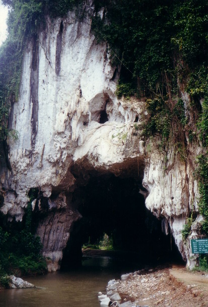
Tham Krachaeng entrance - go north from Ban Than To, through Ban Ka Sod, then right following the signs. Krachaeng Arch is a 100m long natural arch. Follow the river upstream to the main cave entrance. The entrance is blocked by gours so you have to climb up and over them. The large river passage can be followed to a boulder choke and a route up leads to the continuation of the passage and then the confluence with Tham Lod. The upstream Krachaeng water is noticeably warmer than that in Tham Lod. The cave is generally a straight line passage running S - N. It is constantly large and has some fine flowstones and gours. The upstream boulder choke has been pushed 3 times but remains impenetrable. We have tried to enter the cave from the upstream side where the river sinks, but again this is impenetrable.
Notes - There are 2 spellings used : Krachaeng and Krasang. The river caves are very flood prone as they are part of the catchment for the Bang Lang park. The caves should be avoided during unsettled weather. The monsoon season here is Dec - Jan.
Other caves: Tham Wat Krachaeng, aka Tham Morakhot (Emerald Cave) Go through Krachaeng Arch. Steps lead up to the Buddhist temple which was constructed in 1995. The cave consists of one large chamber, and a climb at the back leads up to a tunnel about 20m long. Upper Meditation Cave Situated above Tham Morakhot. A huge chamber slopes steeply up, and a wooden ladder leads up to a higher chamber which leads to a back entrance. This is used by the monk for meditation. There is a parallel passage with some fine formations. Tham Hma (Dog Cave) Just north of the Ban Lang Park, the entrance can be seen by the left side of the road. Cave was explored in 2000 and is about 120m long.
Nearby attractions : Bang Lang dam - the first hydro-electric project in the southern region. There are magnificent views and recreation facilities including fishing. Bang Lang National Park - includes the 9- tiered Than To waterfall. Sakai Village - a village inhabited by indigenous people. There is a small museum and souvenir shop.
Posted on Caves of Thailand www by Dean Smart and Matt London, 2001.