sign in a cave in Laos
Showing posts with label Saparua. Show all posts

28 July 2011

Caves on Saparua, Maluku, Indonesia

Saparua is a small island off the coast of Ambon, in Maluku (The Moluccas), Indonesia. Known as the Spice Islands, you can still see spices such as nutmeg and clove growing in Maluku. Saparua is one of the 3 Lease Islands, which lie northeast of Ambon.

Ouw is a village in the south easternmost corner of the island and is famous for pottery. Many of the rural houses are made from the sago plant. This house is at Ouw and is very near Ouw Cave.

Concrete steps lead down to Ouw cave.

Inside the dark chamber, locals wash their clothes in the sizeable river. The water is very clear.

The people use smoky kerosene lights. Unfortunately they just leave the empty plastic bags and containers from detergent and toothpaste in the cave.

This lady has certainly done a lot of washing

The cave apparently leads to the coast which is not far away.

On the northwest side of the island, before you reach Kalur, is Goa Puteri Tujuh or Seven Princess Cave. From the road, a track led through farmed land with coral karst rocks scattered in the fields.


Steps lead down to the entrance, which is a large chamber filled with pools of incredibly clear water.


There are supposedly 7 pools, one for each princess. Each pool is separated by rock walls which apparently are dry at times of low water. The water was so clear that at first I didn’t realise it was water, and wondered why the rocks below were green. I took several pictures but they don’t do any justice to the place. Again the locals use this cave for washing and for getting water.

More locals come in


Beyond the village of Kulur are 2 caves, Goa Mandi and Goa Minum (washing and drinking caves). The first cave is used for washing and a concrete platform acts as a bathing place.
Goa Mandi
Father and daughter

Surprisingly there are fish in the water, which is a bit murky presumably from all the soap and shampoo used.

The second cave, Goa Minum, is used as a water supply and concrete steps lead down to a pump.

The water is so clear.

There is a water tank outside the cave, set up by Mercy Corps 2002.


© Liz Price
No reproduction without permission

12 February 2009

Saparua, Maluku - BT

Saparua: An Indonesian isle of harmony

Highly strung: Saparua's 'rumah adat' was built without using nails. The wood pillars, joists and rafters have been tied with natural string. Picture: Liz Price

Sunday, February 8, 2009

AS OUR speedboat approached the island of Saparua, I was surprised to see a new church with an extremely tall cross dominating the waterfront. The beach was lined with prahus boats and the cheerful locals waved as they hoisted the small triangular sail and set off across the bay.

On arrival, our boat was tied to the jetty and as soon as the waiting angkutan (bemo) drivers saw my white face they all tried to get my custom. They were out of luck as my transport had already been arranged by my companions.

It had taken one hour to make the crossing from Ambon to Saparua. Pulau Saparua is one of three islands forming the Lease group, situated to the east of Ambon in Maluku province, Indonesia.

The island Saparua is shaped like a distorted "H" and has roads covering each of the four peninsulas. Being part of the Spice Islands, the main products include nutmeg and cloves, as well as palm sugar and root products. Most people live as farmers or fishermen, unless they have jobs as government officers or teachers.

As we drove through the capital, also called Saparua, I was surprised to see many churches. Although Indonesia is the world's most populous Muslim country, the Ambon area of Maluku is home to many Christians. It's common to see a mosque next door to a church. Around the island there are a few Christian shrines, and also murals painted on walls, some with the word amato, meaning "go safely", and others more amusingly with Happy Christmas as a permanent feature.

Our first stop was Pattimura's house. Pattimura was an Indonesian national hero from the early 19th century and the house has been turned into a simple museum. There is a locked room containing a display cabinet of Pattimura's clothes. The houses in this town are all bungalows, many of which have thatched roofs made from sago leaves.

Driving through the market was interesting as the traders were just sitting in the road with their wares laid out on the ground. There wasn't a lot on offer, a few piles of durian and other fruit, and some yellow fish I hadn't seen before. Dogs strolled by but made no attempt to grab anything.

Saparua is famous for its biscuits, mostly made from sago. Some were quite okay whereas others resembled a small wad of compacted sawdust.

Our next stop was Fort Duurstede. Today just the shell remains, sitting atop a coral hill. It was built in 1676 by the Dutch Governor of Amboina (Ambon) and was later conquered by the hero Pattimura. During this attack, all the Dutch soldiers were killed. Some canons remain, facing out to the bay and cows graze on the grass inside the fort. The stone-walled lockup still remains.

Driving along the southeastern coast, we went through Sirisori, which is divided into Christian and Muslim villages of Sirisori Kristen and Islam.

Just beyond is Ouw, a village famous for its pottery. The potteries are family run and at the one we visited, we were able to watch the lady quickly and skillfully make two pots. The husband was firing some pieces in the kiln.

One of the main items made are the bowls used for papeda, which is the glue-like sago pudding eaten with fish sauce. Some of the items for sale caught my eye, in particular the large vases with intricately carved flower designs.

Having an interest in caves, I wanted to see Ouw Cave. Steps lead down to the entrance, and inside I was surprised to see three locals sitting in the subterranean river, washing their clothes. They use this cave as a water supply, washroom and laundry. The cave is quite dark so the people use homemade kerosene lamps. The water entering the cave was crystal clear, and it was sad to see all the empty detergent and shampoo wrappers left strewn around the cave.

Back in Ouw, we stopped to look at the ruins of the fortress, and I could see at least four churches in one road. It was amazing that such a small village would have so many places of worship. And then just outside the village a new mosque and church were being constructed side by side.

We then went across to Tuhaha and to the oldest church at Noloth. It was built in 1860 and the roof is made of sago palm leaves and amazingly it survived the riots. It was interesting to see an original stone inscribed "bait Allah detahbiskan oleh R.Bossert 1860" (God's house consecrated by Bossert).

Near the church is the rumah adat, which was constructed without using nails. The wood pillars, joists and rafters have been tied with natural string and the sago sheets used for the roof are tied to bamboo supports.

We headed for Kulur on the western side of the island. On the way we stopped to look at Goa Puteri Tujuh. This cave has amazing clear water pools. There are seven, one for each princess. I couldn't believe how clear the water is, and again the locals use the cave for washing.

We went on to the end of Kulur, to Goa Mandi and Minum. The first cave is used for washing and has a concrete platform where the locals can sit. I was surprised to see fish swimming in the soapy water.

The drinking cave is very clean, steps lead to the middle of the pool. Mercy Indonesia has even built a water tank outside.

Booi is the last village on the southernwestern peninsula. The road ends before the village and then you have to walk in. The village is built on the hill slope leading down to the sea and concrete steps connect the different levels, giving it a terraced effect.

After a full day of sightseeing, we went back to the main town and had a delicious dinner of fresh fish. We were all tired and went to bed early as the next day we would have to be up at 5am to catch the ferry back to Ambon.

It had been a great day.

The Brunei Times


18 July 2008

Caves of Moluccas - WildAsia


Cruising the Caves of the Moluccas

After exploring the limestone caves of Saparua and Seram in Maluku, Indonesia, LIZ PRICE gives us a rundown of cave fauna and formations and even explains the local lore of the mysterious Lusiala bat-bird.


[Published on WildasiaWildAsia 4 June 2007]


Maluku, or The Moluccas, in Indonesia are perhaps better known as The Spice Islands. This name originated from the spice trade during which Indian, Chinese, Arab and later European traders frequented the place from as early as the 1st century. In 1999, the Maluku Islands split into 2 provinces: North Maluku and Maluku. I knew about the caves near Halmahera in the North Maluku province, which had been documented in caving journals, but until my trip to Maluku province in 2007, I had no idea about the caves there.

Although not many cavers have been to Maluku, research has been carried out in several archaeological caves there over the years. Archaeological case studies include the Labarisi site (north Buru), the Hatusua site (southwest Seram), and several cave sites on the northern Leihitu Peninsula (Ambon).

The Siwa Lima Museum in Ambon built a replica cave to represent a prehistoric cave in which people used to live. Inside, visitors can look at cave paintings, a fire place, protective wooden gates, enemy skulls etc.

Caves on Seram

Pulau Seram, or Seram Island, is non-volcanic and is the largest island of Maluku. The capital of the district is Masohi. The island covers an area of 18,625 km2 and its highest peak, at 3027 m, is the Gunung Binaya.

The Manusela National Park covers 19% of the island's width, and has some high and densely forested limestone mountains. The formation of the Manusela limestone has not been precisely dated. I came across two reports; one stated that it is Triassic limestone formed during the Paleozoic and early Mesozoic Eras, while the other report (Cooper) writes that its formation dates back to the Early and Middle Jurassic Period. This is equivalent to 190 to 150 million years ago.

Most of the limestone mountains have been unexplored by cavers and there is one unexplored cave right by the roadside. The caves around the coastal villages of Sawai and Saleman, in the northern parts, are better known. Due to the geological formation of the caves, many of them have deep shafts and canyons formed by underground streams. The water supply for these two villages is obtained from several small resurgences. There is a series of stream sinks on the eastern side of Hatu Lusiala, 3 km to the west of Saleman. Resurgences can be found at sea level and up to a height of 50 m above sea level. The boat ride between Sawai and Saleman offers a good view of the 300 m high limestone hills.

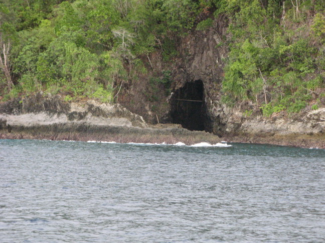
Kampung Saleman is a small Moslem fishing village and tourists are taken to see the evening bat flight from Goa Lusiala. The large entrance is clearly visible high in the cliff of Gunung Polesi behind the village. Every evening flocks of bats leave the cave in an impressive "bat flight". They exit and fly in the shape of a long ribbon over the sea. Unfortunately, the locals seem to think of them as birds, and tourists are taken to see the "Lusiala birds". This 'bird' is sacred to the local community, indicated by its name, 'lusi', which means ancestors, and 'ala', which means descendants. The locals describe these animals as a 'bat-type bird with a tail' and they supposedly leave the cave bearing the souls of the ancestors. The cave is said to be 450 m deep, according to local men who have descended. The SUCC/WCC expedition (see below), however, record it as 80m deep.

Behind the Moslem village of Sawai, there is one cave which is suitable for tourists; Goa Hatu Putih (aka Goa Lasai). It is located within the National Park and is a 40-minute walk away from Sawai. The entrance is in a rock on the hillside, and is a resurgence with 2 small streams coming out. The chamber at the entrance is occupied by fruit bats and non-edible birds' nests. Upon entering the cave, there is a passage with many stal to the left. This leads to a couple of small chambers, which are inhabited by bats and invertebrates such as spiders, whip spiders and ants.
In 1996 there was an international caving expedition to Seram, by SUCC and Wessex Cave Club (WCC, England). They explored many caves in the Saleman/Sawai area and recorded more than 30 caves and resurgences. Many of the caves had deep shafts. According to tourist literature, there are caves near Hatuhuran on West Seram, near Seram Beach Resort.

Goa Akohi, a famous cave in south Seram in Tamilouw, east of Masohi, is full of spectacular stalactites and stalagmites. Large concrete square stepping stones form a path through the cave. The cave is really beautiful. Unfortunately, a new concrete entrance blockhouse has been built over the natural entrance in the last year. Also, electric lighting has been installed recently, powered by a generator located next to the entrance. However, the lights dazzle visitors and the cables were laid without care. Also, much of the workmen's debris has been left in the cave, as well an old concrete staircase. The cave guide found nothing wrong with touching the stal and using them as handholds.

The cave is located right by the roadside and I was told that there are 16 others in the area. The cave is managed by Dinas Pariwisata (Tourism Office). The caretaker can arrange tours for people who turn up at the cave, but it is advisable to pre-book with the Dinas Pariwisata in Masohi before visiting.

Caves on Saparua

Saparua is one of the 3 Lease Islands, which lie northeast of Ambon in Maluku Province, Maluku. Ferries and speedboats leave from Ambon's Tulehu harbour to various ports on Saparua.
The first cave I visited is in Ouw, in the south easternmost corner of the island. I hadn't seen any limestone in the area. Ouw is famous for its pottery. Our drive ended at the far side of the village, from which we walked about 200 m to the concrete steps leading down to a cave. Inside the dark chamber, locals were washing their clothes in the sizeable river. They were using smoky kerosene lamps to light up the place. Unfortunately, they leave their plastic bags, empty detergent containers and toothpaste tubes behind in the cave. The cave apparently leads to the coast which is not far away.

Driving across the top of the island to Kulur on the northwest corner, we passed a cave immediately by the roadside. This may have been Goa Air Serambi. Further on, a local led us to Goa Puteri Tujuh, or Seven Princess Cave. A track led through farmed land with coral karst rocks scattered in the fields. We walked down the steps leading to the cave, and entered a large chamber with several pools filled with incredibly clear water. There were supposed to be seven pools, one for each princess. The water was so clear that, at first, I didn't realise it was water, and wondered why the rocks below were green. I took several pictures but they don't do any justice to the place. Apparently, the pools, which are separated by rock walls, are dry at times of low water. Again, the locals use this cave for washing and obtaining water.

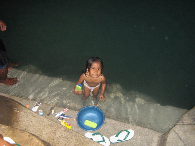
We drove through the village of Kulur and to two caves, Goa Mandi and Goa Minum (washing and drinking caves). The first cave is used for washing and a concrete platform acts as a bathing place. Surprisingly, there were fish in the water. It was murky, presumably from all the soap and shampoo used. The second cave is used chiefly to obtain water and concrete steps lead down to a pump. There is a water tank outside the cave, set up by Mercy Corps in 2002.


© Liz Price - article may only be republished with the author's permission.


References:
COOPER, Ian. 1997. "Seram Geology". SUSS Bull 37/2, The University of Sydney Australia.www.ee.usyd.edu.au/suss/Bulls/37(2)/seramgeology.html
JACKSON, David. "It's a Goa!" Joint SUSS/WCC Seram Expedition Seram, Indonesia: 1st August-7th September 1996. SUSS Bull 37/2, The University of Sydney Australia.www.ee.usyd.edu.au/suss/Bulls/37(2)/seram.html

23 August 2007

Saparua caves - Maluku

Saparua is a small island off the coast of Ambon, in Maluku (The Moluccas), Indonesia. Known as the Spice Islands, you can still see spices such as nutmeg and clove growing in Maluku.

These are the cave photos I took on Saparua.

The first cave was at Ouw. Locals use this cave to do their laundry by the light of smokey kerosine lamps -


Driving across the island we passed a roadside cave -


The next  cave we visited was Goa Puteri Tujuh .


We then went on to Goa Mandi and Goa Minum. These caves are next to each other, and as the names suggest, one is used for washing, the other is used as a source of drinking water.
Goa Mandi -


Goa Minum -

 The water is pumped up to the tank


Some sea caves seen from the ferry from Saparua to Ambon


See also my other albums on Saparua (non cave) and Ambon and Seram and Sawai and Akohi Cave and parrot rehabilitation centre.

© Liz Price
No reproduction without permission