sign in a cave in Laos
Showing posts with label Satun. Show all posts

7 November 2023

Tham Phu Pha Phet, Satun, Thailand

 In 2011 I wrote a blog about Tham Phu Pha Phet in Satun, Thailand, which I had visited with the Axbridge Caving Group in 2001. 

The area now comes under the Satun UNESCO Global Geopark, designated in 2018.

On 6 November 2023, Nature published a report "Unravelling the hidden diversity of cave mycobiota in Thailand’s Satun Geopark". In 2019 researchers had studied the mycobiota or fungi, in two caves in the Geopark, Le Stegodon and Phu Pha Phet Caves.  

From the article :
"Satun Province in southern Thailand, recognized as the "Land of Palaeozoic fossils," became the country's first UNESCO Global Geopark on April 17, 2018. The Satun UNESCO Global Geopark encompasses four districts in Satun Province, known for diverse karst topography and abundant fossils from the Palaeozoic Era. Phu Pha Phet Cave, or "Diamond Mountain Cave," in Satun Province, Thailand, is the country's largest and the world's fourth-largest cave, with a length of 536.65 m and an area of 0.16 hectares. The cave has over 20 chambers with dazzling stalactites and stalagmites resembling diamond flakes, accessed via a wooden bridge and illuminated by lighting. Tourist visits are allowed with restricted access for conservation and sustainable tourism purposes, resulting in limited visitation and moderate human interference."

I don't know the definition of largest cave in this context. It is obviously not length, could be they are referring to volume. 

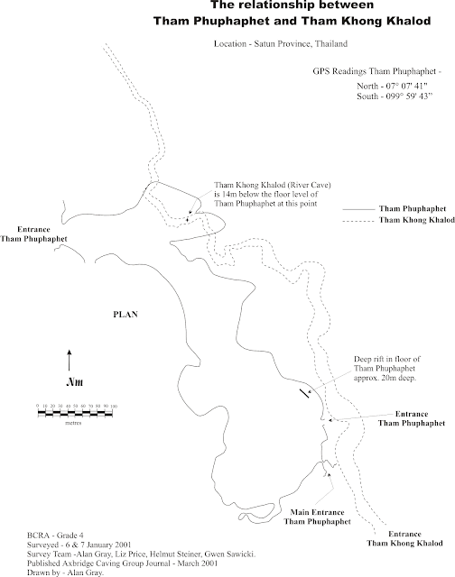
These are the surveys from the 2001 ACG visits :


31 December 2011

Phu Pha Phet Cave, Satun, Thailand

Phu Pha Phet Cave in Satun province, in south Thailand is a very large cave. It is large in terms of volume, or chamber size. [Looking at Google Earth it seems the cave is just over the border in Phattalung province, but the road access is from Satun province!]

In Sept 2000 I saw a signpost to this cave on the road 4137 south of La Ngu, between Ban Prae and Khuan Kalong. However the cave is a long way from here. We started to drive to it but gave up when we saw no sign of any limestone hills.

I mananged to get to the cave in Jan 2001 with the Axbridge Cave Group expedition.

Again we were driving on the 4137 road, but this time we were going north. Although the cave is signposted, there is no distance marked. Our guide said it is 30 km. We drove quite a way, then turned right onto a rough track and saw a sign for 2 caves, Phu Pha Phet and Jetkod, 20 km and 9 km. The road became very poor and we had to go over a very dubious looking bridge.

After some km we came to a sign for Golden Bell Cave on the left.

Golden Bell Cave - we drove down a rough track for a few km, and passed some limestone hills. The cave is in a hill on the right. There was one resident monk.

The first cave was more of a rock chamber with Buddhas, and at the back was a small pool with stal and many toads.

The main cave is further along the track and has electric lighting. A small entrance leads into a complex of large sloping chambers and tunnels. All the upper chambers are reached by wooden ladders made from planks, some with bamboo handrails. There were 2 or 3 beds in the high chambers.

We missed Jetkod Cave, but were told it is a river cave near Golden Bell.

It was still around 20 km to Phu Pha Phet Cave along a very rough track. We seemed to be surrounded by limestone hills most of the way. One tower on the right had an archway right through near the top. Very impressive.

Some of the hills had jagged blocks or pinnacles up hill. All very interesting.

We finally came to a sign to 2 caves, Phu Pha Phet and Tham Khong Khalod.

Phu Pha Phet - the entrance is half way up the hill. A small rock shelter with a low stooping passage leads into the main cave.

The main cave is HUGE. Wooden ladders lead down and only then we realised just how huge the chamber is. Huge stals and lots of blackness in the distance. Everything is very dry.

We walked around the chamber which is packed with stals. 2 guides showed us around. We were in a rush so didn't have time to stop and really look.

However we returned twice more to explore and survey both caves. It was more than a 2 hour drive from La Ngu (70 mins from Pak Bara on tarred road, then 70 mins on the rough track).

Phu Pha Phet is home to bats and invertebrates. At the base of the main chamber a steep slope and climb lead up to a very large opening which is really impressive (pic from Google Earth).

A side passage leads to a chamber and we could hear a river about 50 m below.

The next day we went in Tham Khong Khalod, which is a river cave at the base of the hill. We stopped when we reached deep water with a lot of bamboo and wood debris floating. We could hear the river beyond but didn't fancy the rubbish.

We realised that both these caves are connected, part of the same system. We again went up to Phu Pha Phet to check out some things including a drop into a blind chamber.

We also tried to abseil down to the river but our rope was to short.

At the time there seemed to be nothing written about Phu Pha Phet. Even now it doesn't feature on many websites. I was amused to see this site

Phu Pha Phet Cave is situated in Village number 9 Pa Pon Community Pakm Pattang Subdstrict, Manang, Palm Phattana.
Phu Pha Phet Cave in Thailand is one of the must visited places when you visit Manang district in Satun, Southern Thailand. This well kept secret has only recently been exposed to international tourism and for those who enjoy some serious Eco-Tourism or love caves, this is the place to visit. Also translated as the Diamond Mountain Caves, this is the largest cave in Thailand, the third largest in the world and apparently unavailable in most international travel guide books.


It is not the largest cave in Thailand or 3rd largest in the world. It might however be the 2nd largest chamber in Thailand, and approximately the 16th largest chamber in the world.

A full report was published in ACG Journal March 2001 and the ACG website.

Apparently there are now guided tours into the cave and headlights can be rented, according to this blog and another blog.

© Liz Price
No reproduction without permission

29 December 2011

Thale Ban caves, Satun, Thailand

Thale Ban National Park is in the southernmost province of Satun and borders onto the state of Perlis in Malaysia.

In fact the Perlis State Park compliments Thailand's Thaleban National Park and forms a transboundary park.
Thale Ban Park headquarters are just a couple of kilometres from Malaysia’s Wang Kelian border post in Perlis.

The Nakawan range of limestone hills runs through the west side of Perlis and up into Satun. In Perlis there are many caves in the range, but surprisingly on the Thai side there are few caves.

In 2000 I joined the Axbridge Caving Group (from UK) to explore caves in Thale Ban. In Feb 2000 we did a recce trip and the main expedition was in Dec 2000 - Jan2001.

The best known cave in Thale Ban is Tham Ton Din. It is a 400m long river cave, just across the road from Park HQ. I had been in here on a previous visit in 1999.
Black bands in the bedding

During the recce the caves we found were much smaller.

We went to Wang Prah Meadows and trekked to Tham Padew. We were accompanied by a guy from the Field Force complete with HK automatic rifle which he used as a walking stick on tricky parts. Another guy had a gun in his bag.
Tham Padew is basically a large rock shelter with an 8m long passage at the back. Total length about 35m.

The next cave Tham Nam, was even shorter, about 8m long, but it was an eventful visit. We nicknamed the cave Broken Leg Cave for 2 reasons – inside we saw a toad with one bare femur bone and no flesh, and outside Ronn badly bruised his leg, which lasted more than 2 weeks. Later in a bar a lady gave me some aloe vera toothpaste to rub on the bruise.
There was a hornet nest in the entrance which we had to squeeze past – Martin got stung once on the way in, and I got more than 8 stings on the way out, very painful. The small entrance passage led down to a stream, and we persuaded Martin to do a balancing/traversing act only to find it ends in a sump.

On another day we got a lift to Ban Thung Phatthana on the back of a truck packed with boy scouts.

An old man led us through a rubber estate, dry paddy fields and a swamp to Tham Krun Krang. There was a knee-deep pool outside the cave and a bamboo fence.
We swam through the cave to the other end and explored the side passages, but none went. The cave basically bisects the small hill.

We then hired a truck in the village and went to Tham Peng, which are 2 short caves both going through the hill.

Then we looked at a dragon shaped limestone hill but could find no openings.

Next we explored the longest cave so far, Tham Kubor Duson, which is a tourist cave in a recreation park! This is 22 km north of Satun.
According to this site :
Located in the Village No. 5 in Amphoe Khuan Don and about 22 kilometers from the Satun town, the Duson Irrigation Dike, Satun is a huge reservoir. As you move a further up from the Duson Irrigation Dike, Satun, you would come across a lush green patch of land, steep slopes and caves.

After these short caves, we went over to Koh Tarutao, which is an island in a marine National Park and visited Crocodile Cave, Tham Chorakhe.

© Liz Price
No reproduction without permission

7 November 2011

Crocodile Cave, Ko Tarutao, Thailand

Ko Tarutao is a small island in the Andaman Sea off the west coast of Satun, the southernmost province of Thailand. It is part of Ko Tarutao National Marine Park, which is a large archipelago of 51 islands approximately 30 km from Pak Bara in La-Ngu district, 60 km northwest of Satun town.

The islands are north of Langkawi in Malaysia and form part of the same geological group. In fact the main island of Tarutao is only 5 km from Langkawi. These islands are formed of granite and allied rocks, and there is also much limestone. This limestone is the oldest limestone in the area, some 450 million years old.


Tham Chorakhe or Crocodile Cave is a tourist attraction not to be missed.

A small boat took us up river, past lots of mangroves with occasional limestone cliffs jutting out of the forests.

From the jetty a boardwalk leads over mangrove swamps, then steps go down to the cave entrance. The river enters the cave so a pontoon walkway has been constructed on very noisy polystyrene blocks, which squeaked annoyingly as we walked along. The causeway swayed and wobbled, so I had to make sure I was steady before taking pictures of the stalactite formations.

We came to a large dry chamber and we able to explore this with the help of electric lights. It was a nice cave with a lot of stalactites and stalagmites.

The other tourists turned round and went back out, but we were cavers and we could see the far end of the cave ahead, beckoning us. We were separated from it by mud and water but as we were wearing our old caving shoes we thought it wouldn't be a problem. However we weren't expecting the mangrove mud to be so thick and sticky and glutinous. It took a tenacious hold of our shoes and it was a real struggle to move as with each step we sank in mud above ankle level. We were getting nowhere, so decided to give up. Even getting back to the dry chamber was a real struggle, the mud certainly didn't want to give up its grip on our shoes.

Behind the Park HQ is Toe Boo cliff and this is a great place to climb up to see the views and also the sunsets. We were lucky and had glorious sunsets a couple of evenings.

Ko Rang Nok or Birds Nest Island is a small island off the south coast. Locals collect the swiftlets' nests for the Chinese market. There are some coral reefs off the island. Sea gypsies and pirates once plied these waters, today fishermen try to make a living.

--------
See more on Tarutao.

© Liz Price
No reproduction without permission

19 August 2008

Thale Ban caving - Star

Caving in Thale Ban

THE STAR
Saturday, December 28, 2002

Story and Picture by Liz Price

Wot, wot, wot was the dominant sound each evening and it lasted until dawn when it was replaced by wa wa. I was in Thale Ban National Park in Thailand and these were the sounds made by the local inhabitants – hundreds of frogs living in the lake. Unable to find the real name of the frogs, we soon called them the wot wot frogs, and they provided much amusement each night. I imagined long ago someone had asked them a question and they misheard and said “what”, and this remained the extent of their vocabulary. Each morning at dawn, the gibbons could be heard calling out to each other on the distant hill range. It was a very pleasant sound, the wa wa would reach a crescendo then die away until another gibbon took up the call.

Thale Ban in the Satun province is the southern most park in Thailand – the headquarters, a mere couple of kilometres from Malaysia’s Wang Kelian border post in Perlis. In fact, the Perlis State Park complements Thailand’s Thale Ban National Park and forms a transboundary park. The main geological feature of the Perlis Park is the Nakawan range of limestone hills which run northwards from Kuala Perlis across the border into Thailand. These hills in Perlis are riddled with caves, so it is logical to assume that the caves would continue in Thailand. I went to investigate with a caving friend from Perlis, and a caver from England who had flown out for a holiday cum caving trip.


The Thale Ban Park with limestone mountains.

We checked in at the park headquarters. As we walked alongside the 32ha lake to our bungalow, the wot wot frogs greeted us in a noisy chorus. Our rooms were situated right by the lake, with the limestone mountains forming a backdrop. It was a scenic backdrop. Thale Ban is a lush tropical park, carpeted with a remarkable semi-evergreen rainforest, which features flora and fauna more indigenous to Malaysia and Sumatra. Few people come to Thale Ban for caving – most people are here for birding. Over 200 species of birds inhabit the park, including the peregrine falcon, hawks, and hornbills. Interesting animals such as the mousedeer, white-handed gibbons, and dusky leaf monkeys are sighted regularly.

The park’s headquarters is located in a valley floor between limestone and granite mountains. From this beautiful spot, there are several trails leading to the park’s major scenic places. There are also two impressive waterfalls, and on the southern edge is a mangrove forest. And of course, there are caves.


We were looking for caves.

The best known cave is Tham Ton Din, a 400m long river cave, just across the road from Park HQ. I had explored this cave on a previous visit, and although it is a very pleasant cave, we didn’t go in this time, as we were looking for new caves. Many people in southern Thailand speak Bahasa Malaysia as they are from Malay stock, so it is quite easy to communicate. However, in the park it was different, as most of the staff only spoke Thai. We managed to meet up with one ranger who could speak Bahasa Malaysia and explained that we needed transport to look for caves.

That same afternoon we set off in a truck for a Ranger Station in another part of the park. We were joined by a couple of Field Force guys who came along to escort us, one had a HK automatic rifle, the other had a gun in his shoulder bag. As we climbed up a slippery hill slope, I was a bit perturbed to see the guy with the rifle, who was immediately behind me, using the rifle as a walking stick. I just hoped that the safety catch was firmly in place.

We found one small cave which was so short that it hardly qualified as a true cave. But we had an eventful time exploring it. There was a hornets’ nest in the narrow entrance, which we gingerly passed to enter the cave. As we dropped down into the stream, we saw a toad with one bare femur bone – all the flesh had disappeared. Ugh. After about eight metres, the cave ended in a sump, a place where the water meets the roof. On the way out, I accidentally disturbed the hornets and got stung several times. Outside the cave, Ronn slipped and bruised his leg very badly. We named the cave “Broken Leg Cave” after the toad and Ronn’s legs.

That night we went into Satun for dinner. As we were sitting having a beer, the landlady who is a nurse came out with some ointment for Ronn’s leg. We thought it was some special remedy, sticky and minty, but it turned out to be aloe vera toothpaste!

The next day the truck we had arranged for didn’t appear. We sat around and waited, and whilst wondering what to do, we were suddenly offered a lift on a truck packed with boy scouts. Not wanting to look a gift horse in the mouth, we eagerly climbed aboard, and were soon speeding down the road, hanging on for dear life. After visiting a school, we were dropped off along the roadside, and found an old man who escorted us through the rubber plantation to a cave.


Negotiating obstacles to reach the caves.

The cave was another short one, but entailed swimming through it. We emerged dripping wet, then walked back to the road and flagged down a passing pickup truck. We were able to hire the vehicle to take us around to other sites. Although we found no more caves that day, we did visit a couple of waterfalls. There are two falls which are tourist attractions, the Don Bliew and the Yaroy falls. The former is the most beautiful fall in the Park, about 10km from Park HQ, and has a good year round of water supply. The Yaroy waterfall is a series of five drops, again signposted from the road. We also went to a hot spring which we smelt long before we saw it as the stench of sulphur permeated the air from afar.

The next day we went up to Wang Prah meadows to look for caves. I found the name intriguing as it conjured up an area of meadows filled with wild flowers. Sadly, when we visited, there were no flowers, it was just grassland. It is actually a large area of redundant rice fields which is slowly reforesting. It is supposedly a good place for bird watching.

During our stay, we found a few caves, but none as big or spectacular as those in Perlis. It is strange that although it is the same hill range, the caves seem to stop at the border. Obviously the man-made border didn’t exist when the caves were formed. The caves are some of the oldest in Malaysia, made of 400-million-year- old limestone, so I wonder why the caves didn’t really develop on the Thai side. It is a geological mystery of Mother Nature. E

Tarutao ex penal colony - Star 2003

THE STAR
Saturday, June 07, 2003
Penal colony where pirates used to roam

By Liz Price
WE were going on holiday to a place which used to be a haven for pirates and, more recently, a penal colony and place of detention for political prisoners.

The name of our destination means “old, mysterious and primitive”. Despite the dubious history and name, it turned out to be a stunning place, a beautiful tropical island with golden sands, green seas and wonderful sunsets.

We were on Ko Tarutao.

Only 5km from Langkawi

Ko Tarutao is small island in the Andaman Sea off the west coast of Satun, the southernmost province of Thailand. The island is part of the Ko Tarutao National Marine Park, which is a large archipelago of 51 islands approximately 30km from Pak Bara in La-Ngu district, 60km northwest of Satun town.

The islands are north of Langkawi, and form part of the same geological group. In fact the main island of Tarutao is only 5km from Langkawi. These islands are formed of granite and allied rocks, and there is also much limestone. This means caves. The limestone on these islands are as old as the oldest cave-bearing limestone in Malaysia, some 450 million years old.

My friends had come out from England on a caving expedition-cum-beach holiday. This was a perfect area. We explored one fine river cave on Langkawi, then moved up to Satun, and explored more caves.

Following a hot Thai curry for breakfast, we negotiated a taxi to take us to Pak Bara. It was an ancient but huge car, and we paid less than RM25 for the 60km trip. Pak Bara is geared up for tourists, and we bought ferry tickets to Tarutao and visited the marine park office. It was an interesting 1½-hour boatride as we went past lots of scenic limestone islands and saw several dolphins.

When we arrived on Ko Tarutao, we paid our entrance fee to the Marine Park and bought a guidebook, then organised a room. There is a choice of accommodation from dorms to twins and doubles, and two-room lodges. You can also camp out on some beaches. Park HQ is at Ao Phante Malaka.

Cave with stalactites, stalagmites

Tham Chorakhe or Crocodile Cave is a tourist attraction not to be missed. A small boat took us up river, past lots of mangroves with occasional limestone cliffs jutting out of the forests. From the jetty a boardwalk leads over mangrove swamps, then there are steps down to the cave entrance.

The river enters the cave, so a pontoon walkway has been constructed on very noisy polystyrene blocks, which squeaked annoyingly as we walked along. The causeway swayed and wobbled, so I had to make sure I was steady before taking pictures of the stalactite formations. We came to a large dry chamber and were able to explore this with the help of electric lights. It was a nice cave with a lot of stalactites and stalagmites.

The other tourists turned round and went back out, but we were cavers, and the far end of the cave ahead beckoned us. We were separated from it by mud and water but as we were wearing our old caving shoes we thought it wouldn’t be a problem.

However we weren’t expecting the mangrove mud to be so thick and sticky. It took a tenacious hold of our shoes, and it was a real struggle to move as with each step we sank in mud above ankle level. We were getting nowhere, and so decided to give up. Even getting back to the dry chamber was a real struggle, the mud certainly didn’t want to give up its grip on our shoes.

Wildlife and marine life

None of the islands in the Marine Park has been allowed to be developed by private operators. Only five of the islands have a regular boat service, and only three of these – Tarutao, Adang and Lipe – are generally visited by tourists. Tarutao is the biggest and has waterfalls, inland rivers, caves, beaches and protected wildlife. Wildlife on the island includes dusky langur, mousedeer, wild pig, fishing cat and crab-eating macaque.

In Crocodile Cave we saw crabs and mice. Marine life includes dolphins, dugongs, lobsters and turtles. Four types of turtle lay their eggs on the beaches between September and April.

Chequered history

The island was a place of exile for political prisoners from 1939 to 1947, and the remains of the prison can be seen on the southern tip of the island and the middle of the east coast. There is also a graveyard, charcoal furnaces and fermentation tanks for making naam plaa or fish sauce. Many prisoners were revolutionary groups who had held unsuccessful coup attempts. Escape from the island was a grim prospect, due to the sharks, crocodiles and fierce guards.

The political prisoners enjoyed an open prison atmosphere separate from the common convicts. One third of the convicts died on the island, many from malaria. During the Second World War, order broke down. Supplies no longer came from the mainland and both guards and prisoners soon became the most feared pirates in the area, preying on merchant ships as they sailed through the Straits of Malacca.

After the war, British naval troops were sent to Tarutao to clean out the pirate groups. The prisons were closed, and villagers from the mainland began to settle on the island and became fishermen and farmers.

In 1974 Tarutao became Thailand’s second marine national park. The villagers were unhappy about this, and most moved away, leaving just 17 families.

Surprises

A road runs down the length of the island. Some 11km of its length was built by the prisoners in the 1940s, while the more recent 12km was constructed by the park division. Today the road is mostly overgrown but park personnel have kept a path open to make it easier to get from north to south without having to climb over rocky headlands along the shore.

We decided to look for some other caves we had read about, one of which was Tham Tarun. We walked along the road, and it was hard work in the sun especially on a long, uphill stretch. Downhill was OK but we realised we’d missed the cave, as we’d come down to sea level, and saw signboards to beaches and waterfalls. So we slogged back up the hill and explored a small cave we found near the road. We had almost reached the top of the hill when a 10-ton truck came along and gave us a lift back to HQ. We were very thankful.

We did little else that day except swim and look round the information centre and library. Tarutao’s library is a goldmine of science textbooks and 19th century English literature. The visitors’ centre has natural history exhibits and information about the prison era, as well as a scale model of the park.

Behind the Park HQ is Toe Boo cliff, and this is a great place to climb up to see the views and also the sunset. It is an area of limestone, with mini cliffs and holes, but no real caves. We were lucky and had glorious sunsets a couple of evenings.

Ko Tarutao is definitely worth a visit as it doesn’t suffer from mass tourism and remains unspoilt. And as it is so close to Malaysia, it is easily reached by road and boat.


Fact File
When to go: Officially Ko Tarutao is only open from November to May when there is a regular boat service from Pak Bara, twice a day. Visitors who show up during the monsoon can stay in the park accommodation if they have their own food.
Where to stay: The bungalows can be booked in advance at Pak Bara, or else booked upon arrival on the island. They are more expensive than in other parts of Thailand, and the restaurant is pricey, so make sure you bring enough money – we ran out of the baht but luckily the park staff were willing to change for us.

For those who don’t want to go alone, tours can be arranged from Satun or Trang.

How to get there: To get to Satun by road, the closest border crossing is Wang Kelian in Perlis; then it is about 40km to Satun town. Or you can reach Satun by boat from Langkawi or Kuala Perlis. Satun to Pak Bara jetty is about 60km.

Taxis leave from near the Satul Thanee Hotel and cost 30 (RM2.70) baht per person. Bus is 18 baht.

By boat: Boats from Tarutao to Pak Bara leave regularly between November and April, at 10.30am and 3pm . Return fare is 200 baht (RM18). Takes 11/2-2 hours, depending on the boat; food and drinks are available on board.

Extra boats may run during peak times.

18 July 2008

Tarutao Park - WildAsia 2006

Tranquil and Teeming Tarutao Park

[Published on wildasia 2 Oct 2006]

The name means "old, mysterious and primitive" and it was once a haven for pirates, a penal colony and a detention centre for political prisoners. Despite its dubious history, Tarutao is a beautiful tropical island with golden sand, green seas and wonderful sunsets. A mesmerized LIZ PRICE shows you the sites.

We were going on holiday to a place which used to be a haven for pirates and more recently a penal colony and place of detention for political prisoners. The name of our destination means "old, mysterious and primitive". Despite its dubious history and name it turned out to be a stunning place, a beautiful tropical island with golden sands, green seas and wonderful sunsets. We were on Ko Tarutao.

Ko Tarutao is a small island in the Andaman Sea off the west coast of Satun, the southernmost province of Thailand. It is part of Ko Tarutao National Marine Park, which is a large archipelago of 51 islands approximately 30 km from Pak Bara in La-Ngu district, 60 km northwest of Satun town. The islands are north of Langkawi and form part of the same geological group. In fact the main island of Tarutao is only 5 km from Langkawi. These islands are formed of granite and allied rocks, and there is also much limestone. This means caves. The limestone on these islands is the oldest cave bearing limestone in Malaysia, some 450 million years old.

From Satun we paid 250 baht (RM25) for a taxi to Pak Bara. Pak Bara is geared up for tourists and we bought ferry tickets to Tarutao, and visited the Marine Park office. It was an interesting one and a half hour boat ride as we went past lots of scenic limestone islands and saw several dolphins.

When we arrived on Ko Tarutao we paid our entrance fee to the Marine Park and bought a guide book, then organized a room. There is a choice of accommodation from dorms, to twins /doubles, and 2-room lodges. You can also camp on some beaches. Park HQ is at Ao Phante Malaka.
Tham Chorakhe or Crocodile Cave is a tourist attraction not to be missed. A small boat took us up river, past lots of mangroves with occasional limestone cliffs jutting out of the forests. From the jetty a boardwalk leads over mangrove swamps, then steps go down to the cave entrance.

The river enters the cave so a pontoon walkway has been constructed on very noisy polystyrene blocks, which squeaked annoyingly as we walked along. The causeway swayed and wobbled, so I had to make sure I was steady before taking pictures of the stalactite formations. We came to a large dry chamber and we able to explore this with the help of electric lights. It was a nice cave with a lot of stalactites and stalagmites.

The other tourists turned round and went back out, but we were cavers and we could see the far end of the cave ahead, beckoning us. We were separated from it by mud and water but as we were wearing our old caving shoes we thought it wouldn't be a problem. However we weren't expecting the mangrove mud to be so thick and sticky and glutinous. It took a tenacious hold of our shoes and it was a real struggle to move as with each step we sank in mud above ankle level. We were getting nowhere, so decided to give up. Even getting back to the dry chamber was a real struggle, the mud certainly didn't want to give up its grip on our shoes.

Fortunately none of the islands in the Marine Park have been allowed to be developed by private operators. Only 5 of the islands have a regular boat service and only 3 of those are generally visited by tourists, Tarutao, Adang and Lipe. Tarutao is the biggest and has waterfalls, inland rivers, caves, beaches and protected wildlife. Wildlife on the island includes dusky langur, mousedeer, wild pig, fishing cat and crab-eating macaque. In Crocodile Cave we saw crabs and mice. Marine life includes dolphins, dugongs, lobster and turtles. Four types of turtle lay their eggs on the beaches between September and April.

The island was a place of exile for political prisoners from 1939 to 1947 and remains of the prison can be seen on the southern tip of the island, and the middle of the east coast. There is also a graveyard, charcoal furnaces and fermentation tanks for making naam plaa or fish sauce. Many prisoners were revolutionary groups who had held unsuccessful coup attempts. Escape from the island was a disheartening prospect, due to the sharks, crocodiles and fierce guards. The political prisoners enjoyed an open prison atmosphere separate from the common prisoners. One third of the convicts died on the island, many from malaria. During the Second World War, order broke down. Supplies no longer came from the mainland and both guards and prisoners soon became the most feared pirates in the area, preying on merchant ships as they sailed through the Straits of Malacca.

After the War, British naval troops were sent to Tarutao to clean out the pirate groups. The prisons were closed, and villagers from the mainland began to settle on the island and became fishermen and farmers. In 1974 Tarutao became Thailand's second Marine National Park. The villagers were unhappy about this and most moved away, leaving just 17 families.

A road runs down the length of the island. 11 km of its length was built by the prisoners in the 1940's, and the more recent 12 km constructed by the park division. Today the road is mostly overgrown but park personnel have kept a path open to make it easier to get from north to south without having to climb over rocky headlands along the shore.

We decided to look for some other caves we had read about, one of which was Tham Tarun. We walked along the road and it was hard work in the sun especially on a long, uphill stretch. Downhill was OK but we realized we'd missed the cave, as we'd come down to sea level, and saw signboards to beaches and waterfalls. So we slogged back up the hill and explored a small cave we found near the road. We had almost reached the top of the hill when a 10 ton truck came along and gave us a lift back to HQ. We were very thankful.

We did little else that day except swim and look round the information centre and library. Tarutao library is a goldmine of science textbooks and 19th century English literature. The visitors centre has natural history exhibits and information about the prison era, as well as a scale model of the park.

Behind the Park HQ is Toe Boo cliff and this is a great place to climb up to see the views and also the sunsets. It is an area of limestone, with mini cliffs and holes, but no real caves. We were lucky and had glorious sunsets a couple of evenings.

Ko Rang Nok or Birds Nest Island is a small island off the south coast. Locals collect the swiftlet nests for the Chinese market. There are some coral reefs off the island. Sea gypsies and pirates once plied these waters, today fishermen try to make a living.

Ko Tarutao is definitely worth a visit as it doesn't suffer from mass tourism and remains unspoilt. And it is so close to Malaysia, it is easily reached by road and boat.

Facts For The Visitor
Officially Ko Tarutao is only open from November to May when there is a regular boat service from Pak Bara, twice a day. Visitors who show up during the monsoon can stay in the park accommodation if they have their own food. The bungalows can be booked in advance at Pak Bara, or else booked upon arrival on the island. They are more expensive than in other parts of Thailand, and the restaurant is pricey, so make sure you bring enough money - we ran out but lucky the Park staff were willing to change for us. For those who don't want to go alone, tours can be arranged from Satun or Trang.

© Liz Price - article may only be republished with the author's permission.

10 May 2008

Tarutao Park, Thailand - BT

This was originally published in the The Brunei Times

© Liz Price
No reproduction without permission

Thai archipelago's unspoilt Tarutao National Park


Stunning: Despite its past as a penal colony, Thailand's Ko Tarutao is a beautiful tropical island with golden sands, green seas and wonderful sunsets. Picture: Liz Price

Sunday, April 27, 2008

WE SPENT part of our holiday in a place which used to be a haven for pirates and more recently a penal colony and place of detention for political prisoners. The name of this place means "old, mysterious and primitive". Despite its dubious history and intriguing name it turned out to be a stunning place, a beautiful tropical island with golden sands, green seas and wonderful sunsets. We were on Ko Tarutao.

Ko Tarutao is a small island in the Andaman Sea off the west coast of Satun, the southernmost province of Thailand. It is part of Ko Tarutao National Marine Park, which is a large archipelago of 51 islands approximately 30 km from Pak Bara in La-Ngu district, 60km northwest of Satun town. The islands are north of Langkawi in Malaysia and form part of the same geological group. In fact the main island of Tarutao is only five kilometres from Langkawi. These islands are formed of granite and allied rocks, and there is also much limestone. This limestone is the oldest limestone in the area, some 450 million years old.

In Satun we negotiated a taxi to take us to Pak Bara. It was an ancient but huge car and we paid about eight dollars for the 60km trip. From Pak Bara it was an interesting one and a half hour boat ride as we went past lots of scenic limestone islands and saw several dolphins.

Arriving in Ko Tarutao we paid our entrance fee to the Marine Park and bought a guide book, then organised a room. There is a choice of accommodation from dorms, to twins /doubles, and two-room lodges. You can also camp on some beaches. Park HQ is at Ao Phante Malaka.

Tham Chorakhe or Crocodile Cave is a tourist attraction not to be missed. A small boat took us up river, past lots of mangroves with occasional limestone cliffs jutting out of the forests. From the jetty a boardwalk leads over mangrove swamps, then steps go down to the cave entrance. The river enters the cave so a pontoon walkway has been constructed on very noisy polystyrene blocks, which squeaked annoyingly as we walked along. The causeway swayed and wobbled, so I had to make sure I was steady before taking pictures of the stalactite formations. We came to a large dry chamber and we able to explore this with the help of electric lights. It was a nice cave with a lot of stalactites and stalagmites.

The other tourists turned round and went back out, but we were cavers and we could see the far end of the cave ahead, beckoning us. We were separated from it by mud and water but as we were wearing our old caving shoes we thought it wouldn't be a problem. However we weren't expecting the mangrove mud to be so thick and sticky and glutinous. It took a tenacious hold of our shoes and it was a real struggle to move as with each step we sank in mud above ankle level. We were getting nowhere, so decided to give up. Even getting back to the dry chamber was a real struggle, the mud certainly didn't want to give up its grip on our shoes.

Fortunately none of the islands in the Marine Park have been developed by private operators. Only five of the islands have a regular boat service and only three of those are generally visited by tourists, Tarutao, Adang and Lipe. Tarutao is the biggest and has waterfalls, inland rivers, caves, beaches and protected wildlife. Wildlife on the island includes dusky langur, mousedeer, wild pig, fishing cat and crab-eating macaque. In Crocodile Cave we saw crabs and mice. Marine life includes dolphins, dugongs, lobster and turtles. Four types of turtle lay their eggs on the beaches between September and April.

The island was a place of exile for political prisoners from 1939 to 1947 and remains of the prison can be seen on the southern tip of the island, and the middle of the east coast. There is also a graveyard, charcoal furnaces and fermentation tanks for making naam plaa or fish sauce. Many prisoners were revolutionary groups who had held unsuccessful coup attempts. Escape from the island was a disheartening prospect due to the sharks, crocodiles and fierce guards. The political prisoners enjoyed an open prison atmosphere separate from the common prisoners. One third of the convicts died on the island, many from malaria. During WWII, order broke down. Supplies no longer came from the mainland and both guards and prisoners soon became the most feared pirates in the area, preying on merchant ships as they sailed through the Straits of Malacca.

After the War, British naval troops were sent to Tarutao to clean out the pirate groups. The prisons were closed, and villagers from the mainland began to settle on the island and became fishermen and farmers. In 1974 Tarutao became Thailand's second Marine National Park. The villagers were unhappy about this and most moved away, leaving just 17 families.

A road runs down the length of the island. 11km of its length was built by the prisoners in the 1940's, and the more recent 12km constructed by the park division. Today the road is mostly overgrown but park personnel have kept a path open to make it easier to get from north to south without having to climb over rocky headlands along the shore.

The visitors centre has natural history exhibits and information about the prison era, as well as a scale model of the park. There is also an information centre and a library which is a gold mine of science textbooks and 19th century English literature.

Behind the Park HQ is Toe Boo cliff and this is a great place to climb up to see the views and also the sunsets. We were lucky and had glorious sunsets a couple of evenings.

Ko Rang Nok or Birds Nest Island is a small island off the south coast. Locals collect the swiftlets' nests for the Chinese market. There are some coral reefs off the island. Sea gypsies and pirates once plied these waters, today fishermen try to make a living.

Ko Tarutao is definitely worth a visit as it doesn't suffer from mass tourism and remains unspoilt. And it is so close to Malaysia, it is easily reached by road and boat.The Brunei Times

© Liz Price