sign in a cave in Laos

29 January 2012

Tham Krachaeng-Lod, Yala, Thailand

In the 1990s I went caving in Yala province on several occasions. One cave I visited several times was Tham Krachaeng.

At the time (1993) Tham Krachaeng was the 6th longest cave in Thailand (now it is 7th) at 5,633m. It is located near Ban Than To in Yala province. Ban Than To is roughly halfway between Yala and Betong on route 410[6].

There are two main entrances, the side entrance sink, Tham Lod, and the
resurgence, Tham Krachaeng. By road these are 10 km apart.

To reach Tham Krachaeng resurgence, you walk through Krachaeng Arch which is a 100m long natural arch.
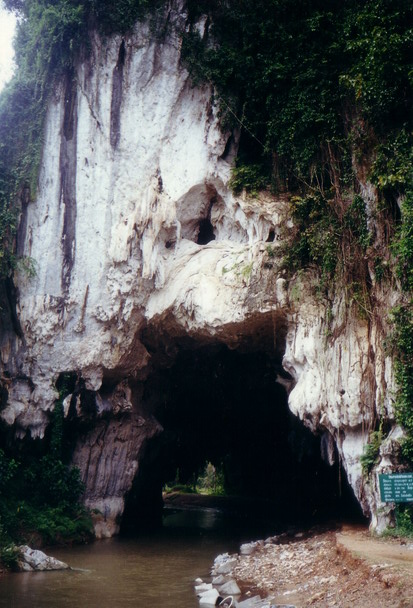
View from inside

Having gone through this cave, turning to the right, steps lead up to the Buddhist temple which was constructed in 1995. The cave consists of one large chamber, and a climb at the back leads up to a tunnel about 20m long.

However Tham Krachaeng is straight ahead following the river. The entrance is blocked by gours so you have to climb up and over them. The large river passage can be followed to a boulder choke and a route up leads to the continuation of the passage and then the confluence with Tham Lod.

Tham Lod is a sink and a 620m long passage leads to the main confluence. This passage is very flood prone and great care should be taken during the rainy season.

There are huge tree trunks and branches and other debris. I even saw banana plants struggling to survive

and coconuts that were shooting - note they have been deposited on a high ledge at least 2 m above the floor

The water is deep in some areas

The place where the water sinks is some distance away and is impenetrable


See more on the ACG expedition 2000.

© Liz Price
No reproduction without permission

Train to Batu Caves

The regular train service to Batu Caves started in July 2010. At that time I visited the Batu Caves station but didn't go on the train.

I finally made the train journey in Jan 2012, just 10 days before Thaipusam. I took the train from Sentral. It is the regular KTM Komuter train and runs every half hour.

This train has a ladies only coach in the middle. However on both journeys there were men in this coach and no one seemed to bother.

The journey from Sentral to Batu Caves took about half an hour and cost RM2.

At Batu Caves there was a YTL cement train carrying away part of the hill!

Inside Batu Caves station

Platform views

The station

Entrance to station

View of Batu Caves from the rail track

© Liz Price
No reproduction without permission

26 January 2012

Flying around Ipoh's limestone hills

In 2005 a friend invited me to join him on a flight from KL to Ipoh in his 2-seater plane. This was the 2nd time I was able to look at the Ipoh limestone hills from the air, first time was on the 2001 expedition.

In the 2-seater it was quite hard to take photos through the window as the plane was bouncing around a lot and I was not able to hold the camera steady.


Gunung Tambun and the Bougainvillea Club

© Liz Price
No reproduction without permission

24 January 2012

Aerial views of Gunung Lanno and Rapat, Perak

In 2001 during the Lanno expedition we were able to hire a 4-seater plane and fly around Gunung Lanno. This gave us a good perspective of the hill from different angles.


We flew from Ipoh airport. First we passed Gunung Rapat and Terendum before reaching Lanno in a couple of minutes.

This is Gunung Rapat. The Kwan Yin temple is on the extreme left side of the hill

This is the area that leads into the wang with the chemical plant, and goes on to the back door of Kek Look Tong
This is a better view of the wang, and Kek Look Tong back garden is at the back of the photo.

This is the south end of Gunung Rapat

Gunung Terendum is the next hill. It is heavily quarried.
This Google Earth image shows the same view (the GE images are 2003)

This lake is by the road that runs between Terendum and Lanno

This is the lake that is in front of Gua Puncak, on the north (central) side of Lanno

The north end of Lanno has been quarried

This is the northwest side of Lanno that faces the road (and my friend's factory is the one with the red roof!)

We circled Lanno again and again, going clockwise from the top, and getting lower which each circle.


The Sg Raia which flows south down the west side of Lanno before turning west

NE end of Lanno

This is the area in front of Gua Puncak again


The hill is impressive with lots of wangs and valleys. We only saw one flooded wang, which is where the Thai Monk Cave is located.

© Liz Price
No reproduction without permission